
Maps published by the National Weather Service (NWS) offer clues on how an upcoming El Niño event could shape weather conditions across the United States.
The weather phenomenon, part of a recurring global weather cycle, can influence temperature and precipitation in the U.S. and globally.
"El Niño is likely to emerge soon," the Climate Prediction Center said in its latest update, giving an 82 percent chance of emergence between May and July.
What Is El Niño?
El Niño represents the warm stage of a natural climate cycle in the tropical Pacific called the El Niño–Southern Oscillation (ENSO). This cycle swings irregularly every two to seven years, altering ocean temperatures and disrupting typical wind and rainfall patterns across the tropics. These shifts in the seasonal climate of the Pacific—the world’s largest ocean—can trigger wider global impacts.
This time round, meteorologists say an especially strong or "super" El Niño could emerge, which could amplify its impacts.
NWS Maps Show Typical El Niño Patterns
The maps depict three‑month average temperature and precipitation anomalies from November through April for weak, moderate and strong El Niño events since 1950, based on 1981–2010 climate normals. They are not forecasts, but historical composites showing where ENSO has tended to influence conditions.
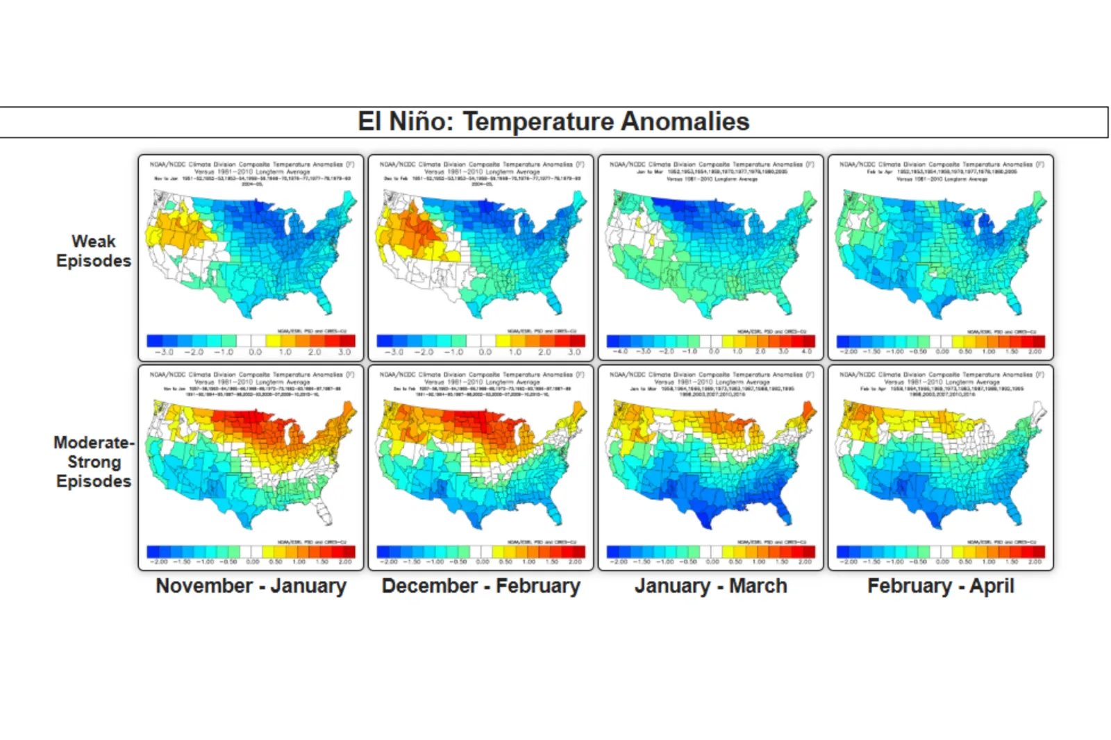
For weaker El Niño episodes, the maps show more modest and regionally confined temperature shifts. The most consistent signal appears in parts of the northern Rockies and northern Plains, where warmer-than-average conditions (shown in yellow and orange shading) emerge, particularly in the earlier part of the season between November February. Elsewhere, much of the country leans cooler than average.
During moderate to strong El Niño events, the pattern becomes far more pronounced. The maps indicate a broad swath of above-average temperatures stretching across the northern tier of the U.S.—from the Pacific Northwest through the Great Lakes and into the Northeast. In these stronger events, the warm anomalies intensify (deep oranges and reds) and expand geographically, peaking between December and February before gradually weakening into early spring.

For precipitation, the maps suggest weak El Niño events show the strongest dry anomalies from eastern Texas through the lower Mississippi Valley and into the Ohio Valley from November through February. Wetter-than-normal conditions are most consistent along the West Coast and parts of the Southeast.
Moderate to strong El Niño events produce widespread wet anomalies across the southern tier, especially California, the Gulf Coast, the Southeast, and Florida. The strongest dry anomalies appear in the Ohio Valley, Great Lakes, and Pacific Northwest.
How El Niño Could Affect US
Newsweek previously spoke with meteorologists on how El Niño could influence weather across the country.
Chad Merrill, and AccuWeather meteorologist explained it could lead to increased flooding risks in some regions, and worsening heat, drought and wildfire conditions in others.
"For the summer, a consequence of El Niño will be a hotter and drier pattern in the Northwest U.S. that can lead to large wildfires," Merrill said.
"Additionally, severe drought can expand across more of the Northwest into the northern part of the Rockies during El Niño summers that transition to a strong to very strong El Niño by the fall to early winter."
The meteorologist also said that El Niño could combine with a marine heat wave off the West Coast to potentially produce more thunderstorms than typical for Southern California.
Additionally, Merrill said it usually brings six- to seven-day stretches of dry conditions followed by heavy rain pockets to the East.
"The stretches of dry weather can lead to a prolonged moderate to severe drought from the I-81 corridor in the Mid-Atlantic into the Southeast.
"Since the rain may come in large quantities over a short time period, there may not be much percolation into the soil to help the agricultural communities."
El Niño could also influence this year’s hurricane season, with Matthew Rosencrans, NOAA’s lead for it’s seasonal hurricane outlook telling Newsweek that the weather phenomenon is associated with fewer tropical storms and hurricanes in the Atlantic but increased activity during the eastern and central Pacific hurricane seasons.
Experts Warn of Local Impacts
Experts have also warned that El Niño could bring sharply different local effects, with Texas more likely to see a cooler, wetter winter and Arizona facing a hotter, drier summer with heightened wildfire risk.
Joel Lisonbee, NOAA’s southern plains drought coordinator, told Texas Standard that Texas typically turns wetter from late fall into early spring during El Niño years. In Arizona, AZ Mirror reported that experts cautioned the state may be in for more record heat, deadly floods and intense wildfire activity this year, with forecasters warning that a strong El Niño could further amplify those risks.